geotiff and .shp files
 Koala
13 Feb 2014
Koala
13 Feb 2014
Hello,
I am using Nanocad for a few months and so far I am very happy with it. However there is new project coming in and I would like to ask a few questions:
a) Is it possible to use georeferenced TIFF („GEOTIFF”) in nanoCAD?
 Is it possible to use „GEOTIFF” images in nanoCAD together with external cordinate system (USC)?
c) Is it possible to convert .shp to dwg. and vice versa?
d) Is it possible to work with .shp files in NanoCAD, and if yes how to import .shp files to nanoCAD
So far I am using free version, but I am seriously considering buying nanoCAD plus so if answers to this questions are different according to the version, please let me know.
Kind regards
Koala
I am using Nanocad for a few months and so far I am very happy with it. However there is new project coming in and I would like to ask a few questions:
a) Is it possible to use georeferenced TIFF („GEOTIFF”) in nanoCAD?
Is it possible to use „GEOTIFF” images in nanoCAD together with external cordinate system (USC)?c) Is it possible to convert .shp to dwg. and vice versa?
d) Is it possible to work with .shp files in NanoCAD, and if yes how to import .shp files to nanoCAD
So far I am using free version, but I am seriously considering buying nanoCAD plus so if answers to this questions are different according to the version, please let me know.
Kind regards
Koala
 Hellen_V
14 Feb 2014
Hellen_V
14 Feb 2014
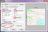
Hello Koala,
a-b ) Yes, it's possible. Insert the geotiff image (Raster - Image from file). Make sure the settings are correct (watch the picture below)
c-d) These functions are not available now, we plan to make them for the future versions of NanoCAD.
a-b ) Yes, it's possible. Insert the geotiff image (Raster - Image from file). Make sure the settings are correct (watch the picture below)
c-d) These functions are not available now, we plan to make them for the future versions of NanoCAD.